

The trail from El Chalten to the unique, rugged mountain Fitz Roy is one of the best in the Los Glacieres National Park - the part of Argentinian Patagonia (the main attraction of which is the amazing Perito Moreno Glacier). Fitz Roy is probably the most distinctive summit in the country - it consists of extremely sharp, triangular-shaped, pointy peaks that can be seen from afar along the beautiful hike. The town of El Chalten is a perfect base for hiking and the treks around are not only quite easy and affordable, but also are an amazing warm-up before doing the more difficult and exhausting W-Trek in Chile's Torres del Paine National Park.
The Best trails from El Chalten in Argentinian Patagonia
As I've mentioned, the remote town of El Chalten is a perfect base for trekking. To get to El Chalten, you must take a bus from the center of the region - the town of El Calafate. A journey from El Calafate to El Chalten takes around 3 hours and costs approximately 20 EUR/22 USD one way.
Unlike in the Chilean Torres del Paine, El Chalten is a real town and not just a mountain hostel (in Chile, to do the hike, you must pre-book your accommodation in overpriced hostels called "refugios" or camp - there are no towns around. You can also camp for free). Because El Chalten is an actual village, the accommodation there is cheaper - it won't break the bank. The best thing is that you can actually start from your hotel and come back there in the evening - this is the reason I would recommend to do such a warm up in El Chalten before the W-Trek. Of course, if you're a passionate hikers, there are also longer and more difficult trails.
There are two main mountains to be admired in the El Chalten Vicinity: the aforementioned Fitz Roy and and Cerro Torre. Both have similar shapes but Fitz Roy is definitely more distinctive. If you're staying more than 2 days in El Chalten, of course, I would suggest that you visit both. But if you're not lucky with the weather and you have to choose which one to see - do the Fitz Roy.
It's a bit crazy to say, but our hike to Fitz Roy was a pure coincidence. The only thing we had planned to see in the Argentinian part of Patagonia was the incredible Perito Moreno glacier near the town of El Calafate. Initially, we intended to stay there for two days, but, to our surprise, we've visited Perito Moreno quite quickly on the first day and a friendly staff member from El Calafate hostel advised that we really should see Fitz Roy. We hadn't even known about it at that time. But we decided to change our plans and book the bus to El Chalten and off we went! I love such spontaneous trips and this turned out to be one of the best surprise ever!
How long does it take to to the trail from El Chalten to Fitz Roy
Let's be precise - the trek described here won't lead you to the top of the Fitz Roy (I marked it as number 9 on the map) - but you will have a chance to see one of the most beautiful viewpoints of the Fitz Roy peaks as well as intensely blue glacier lakes.
We arrived in El Chalten in the morning, before the noon, started the trail and came back in the late evening - around 9 pm. The sun doesn't set until very late during the Patagonian Summer, so you don't have to worry about how long the trek takes. We stayed overnight in El Chalten. To sum up, one day is more than enough to do this trail in a slow, relaxing manner. A return trip would take 8-10 hours.
The trail

The map of the trail
I made a map of the trail on a screenshot from Google Maps. I couldn't find an exact trail anywhere so I marked more or less where it leads so you can see it more clearly. The blue part (first 9 km is the easy part - the read one - 1 last km is the tough, extremely exhausting and steep part).
The great thing about the Fitz Roy trail is that you don't need any additional transport to reach the starting point of the trail. El Chalten (marked as number 1 on the map) is so tiny that you can basically start hiking from your hostel or anywhere in the village.
The whole trail is around 10 km (6 miles) long one way. It's very well marked and you will be notified when you pass each kilometer. The first 9 kilometers are very easy and pleasant. Almost like a regular walk in the woods with a few hills here and there. At first, you have to hike a bit through the forest where you can see some nice views over El Chalten and the valley on the other side (number 2 on the map - Mirador Rio de las Vueltas).
Then, around half way, the trail splits into two parts - take a look at the map. The first leads to the lake Capri (number 3 on the map) The second will take you through the Fitz Roy Mirador (number 4 on the map) - the viewpoint. However, wherever you go, the views will be amazing. There is no one definite point where with the view. I would recommend that you do the lake first on the way up and the Mirador while going back (or the other way around, if you wish - depending on the weather - whenever it's clear, do the mirador part).
You'd think that this amazing natural paradise don't have any downsides. However, there is one - the weather. Unfortunately, if the peaks of Fitz Roy are covered by the clouds, the whole trip may seem worthless. And Patagonia is extremely unpredictable. Overall, the Argentinian part, located a bit more towards the north than Chile, has a slightly milder climate. When we visited El Chalten (in November), it was a bit windy but very pleasant - at least comparing to the Chilean W-Trek where we experienced real hardcore, extreme conditions. But the clouds (when there are not too many of them), are exceptional in Patagonia. Yes, the clouds themselves can be an attraction - however crazy it sounds!
But in all honesty, you must be lucky. In our hostel in El Chalten, we met a tourist from China who did the Fitz Roy trail and said that in Chile, he had attempted to take the bus to to see the Torres del Paine famous mountains for 3 days in a row and everyday they were covered by the clouds so he saw nothing. We were in Argentina before we went to Chile, so our excitement ahead of the W-Trek that was awaiting us was quite strongly subdued. In El Chalten, however, he was very lucky - he had a perfectly clear day and claimed this had been one of the best trails he'd done.
When we started the trail, it was cloudy - not too bad but, of course, the most famous Fitz Roy was covered by the clouds. It was slightly discouraging because the clouds could have covered the whole sky and spared the famous mountain but it was the other way around.
Let's go back to the trail - when we passed the lake Capri (number 3), the weather started to improve and was way more enjoyable, nevertheless, the peak was still covered all the time by just was one stubborn cloud. I was hoping we were not going to repeat the experience from Nepal where almost during the entire trek - we saw nothing.
There's a camp site at the lake Capri, if you wish to camp or take some rest. This lake is not too spectacular - but you can see the Fitz Roy very nicely. Now, you are more or less halfway between El Chalten where you started and the camping points called Pincenot and Rio Blanco (number 6 on the map). Note that from here, you can already spot the beautiful Glacier Piedras Blancas (number 5 on the map). If you have more time, there's a separate trail that will take you closely to the glacier. To be honest, I wish we had done it.
Now, from somewhere around the camps at number 6 on the map - the easy and relaxing part of the trail is over (note that you did the last 9 km in 50% of the time and the next 50% will be dedicated to do just this one last kilometer). The last part is extremely steep and exhausting so take your time. The views are, of course amazing, but when you get to the top - you will be speechless.
Number 7 on the map marks the lake "de los Tres". When we reached this lake, it was still frozen and it was way colder there than in the lower parts - make sure you take a jacket and a hat. I don't have to say anything about the view as you just simply must see it yourself - it's unbelievable.
We thought we had seen the best and then we met other hikers who said that there's another amazing lake around (number 8 on the map) - Laguna Sucia. They also claimed the lake hadn't been frozen - a short walk around was needed to see it. It was so incredible - the lake had a deep blue color and the Fitz Roy (number 9) peaks seemed so close. The clouds were moving around very fast and created an unreal spectacle dancing around the rocks.
Then, right before we started our descent, we had another surprise from the Mother Nature - the clouds (although beautiful) which had been covering the peaks moved away and finally we could see the Fitz Roy in its all glory. The whole way back, it stayed clear. It was one of the most beautiful places in the world. I must say that we returned exhausted but so happy! Worth every effort!

A typical street in El Chalten

El Chalten seen fro the start of the trail

Mirador Rio De Las Vueltas (number 2 on the map)
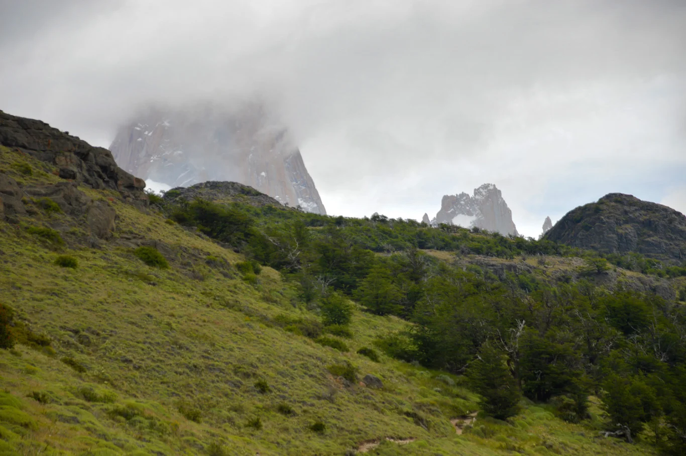
Fitz Roy covered by clouds

Laguna Capri - Fitz Roy covered by clouds - number 3 on the map

Argentinian Patagonia

Fitz Roy

Fitz Roy seen from the trail

Glacier Piedras Blancas (number 5 on the map)

In the vicinity of Poincenot camping site

Poincenot Camping site

Right before the steep part

On the way - right before the steep part

Almost on top - change of the landscape

View from the frozen Laguna de los Tres (number 7 on the map)

Frozen landscape and the clouds

Laguna Sucia

Last look at the beautiful Fitz Roy

Clouds are starting to move away

The whole mountain without clouds

Amazing evening view

Completely clear view of Fitz Roy on the way back - view from the Mirador del Fitz Roy (number 4 on the map)
Author: Tom @ Adventurous Travels
Related Posts


Copying without permission is not allowed. If you wish to use any of the site's content (photos or text) or work with us, please contact us.
We welcome questions, advice, support or criticism. However, spam comments will be removed.